Identity area
Reference code
IT ANPI-PU ANPI-PU-01-7-69-b.134-fasc.69-6-Cartella 4
Title
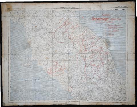
"Carta delle bande partigiane" - 1944
Date(s)
- 1944 (Creation)
Level of description
Item
Extent and medium
Carta geografica 70x100
Context area
Name of creator
Archival history
Immediate source of acquisition or transfer
Content and structure area
Scope and content
Carta geografica dell'Italia centrale 1:500.000 trovata in tasca al capitano tedesco ucciso a Fermignano il 28 giu. 1944. La carta stampata dal Comando tedesco a partire dal 1 aprile 1944 riporta la posizione delle bande partigiane e le strade in cui le truppe tedesche potevano transitare scortate solo di giorno.
Appraisal, destruction and scheduling
Accruals
System of arrangement
Conditions of access and use area
Conditions governing access
Conditions governing reproduction
Language of material
Script of material
Language and script notes
Physical characteristics and technical requirements
Finding aids
Allied materials area
Existence and location of originals
Existence and location of copies
Related units of description
Notes area
Alternative identifier(s)
Access points
Subject access points
Place access points
Name access points
Genre access points
Description control area
Description identifier
Institution identifier
Rules and/or conventions used
Status
Level of detail
Dates of creation revision deletion
Language(s)
Script(s)
Sources
Digital object metadata
Filename
unita.pdf
Media type
Image
Mime-type
application/pdf
Filesize
7.7 MiB
Uploaded
July 16, 2019 8:43 AM